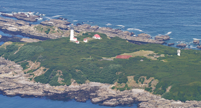
Destruction Island Washington
Destruction Island, a storied landmass along the perilous "shipwreck coast" of the Olympic Peninsula, has a rich and storied past. For thousands of years, the island, originally known by the Quileute name T’achisqu, served as a strategic meeting point during ocean harvests, offering a wealth of natural resources. However, its fame and mystery predominantly originate from its later role as the home to the Destruction Island Lighthouse. This beacon, established in the late 19th century, stood as a sentinel to mariners braving the treacherous waters, its Fresnel lens casting a revolving light every ten seconds from 1892 onwards.
The island fostered a small, resilient community, consisting of lighthouse keepers and their families, who supplemented their rations with livestock and a vegetable garden. Life on Destruction Island was an intertwining of duty and survival, with the lighthouse crew maintaining the critical fog siren and beacon, while a school kept the minds of young inhabitants sharp. The famed Fresnel lens from the lighthouse, an engineering marvel of its time, is now a proud exhibit at the United States Coast Guard Westport Maritime Museum in Westport, Washington, having been replaced by a modern light in 1995.
However, modern technological advancements in navigation and GPS led to the decommissioning of the Destruction Island Lighthouse in 2008. Today, Destruction Island is off-limits to the public, its storied past fading into mystery. The buildings that once teemed with life have succumbed to the elements, leaving only the lighthouse, two oil houses, and a repurposed fog signal building as silent testaments to the island's human history.
Destruction Island's legacy, however, endures in the vibrant ecosystem it supports. It is co-managed by the Olympic National Park and the U.S. Fish and Wildlife Service’s Quillayute Needles Wildlife Refuge. The waters surrounding the island, protected by NOAA’s Olympic Coast National Marine Sanctuary, are a haven for sea otters. Moreover, it is home to the southern-most breeding colony of the burrowing rhinoceros auklet or the "sea parrot." Thus, while its human history may be fading, Destruction Island continues to be a beacon of biodiversity, perpetuating a different kind of mystery for the future.
What is this red square with a symbol on it?
It’s a Helipad used to land Helicopters on the island. In the photo below, taken sometime in the 1970s, you can see a United States Coast Guard Helicopter positioned on the helipad.

The symbol itself is the approach/take-off direction indicator. This indicator is used to help the pilot determine which way the nose of their helicopter should be facing when landing and taking off from the helipad. In the photo, the surface of the helipad appears to be made of steel, which would explain the rust color seen from images of the island.
